12.08.2022
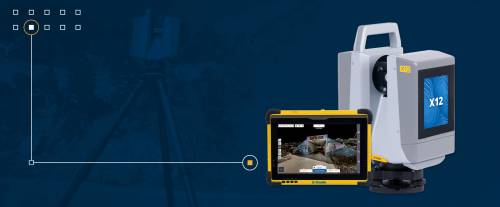
Trimble has added the new Trimble® X12 scanning system to its geodetic scanning portfolio. The X12 combines Trimble's intuitive software for accurate data capture and registration in the field with Zoller+Fröhlich's (Z+F) 3D laser scanning and imaging hardware technology, bringing together the expertise of two industries leaders in a single solution. The Trimble X12 can be operated with Trimble Perspective field software installed on a Trimble T10x tablet to enable registration and refinement of scans in the field, ensuring accuracy and project completion before leaving the job site. Users can also use Trimble's custom software menu to configure and operate the scanner. Data is exported from the field and processed in the office using Trimble RealWorks™ software or third-party software. Final results can be shared online with clients and stakeholders using Trimble Clarity, a browser-based data collaboration and visualization tool. Transforming high-quality 3D data into decisions, such as using scans, models, and images to determine the structural integrity of aging infrastructure is streamlined with the Trimble X12 because data can be stored within the Trimble software ecosystem. This advantage allows users to easily visualize, manage and evaluate the project throughout the workflow, even for novices and new users of scanning technology. With features such as best-in-class range (from 0.3 to 365 meters) and scanning speeds of up to 2.187 million points per second, the Trimble X12 produces scan data and images with unprecedented quality and clarity-which complements the capabilities of the Trimble X7 within the scanning product portfolio.